Preserve
Secure the submitted plan and record the evidence exactly as it was received and relied upon.
 DiKnow TechnologiesUK / Ghana
Site Plan Spatial Verification for Africa*
Making land ownership clear, visible and verifiable. SPV transforms information contained in paper cadastral and site plans into mapped evidence, helping people and organisations identify potential location, boundary, size and environmental risks before they become costly disputes, losses or delays.
Earlier risk identification
Land-related decisions can expose individuals and organisations to serious loss and disruption. SPV provides an early, clearer understanding of the plan evidence so concerns can be investigated and preventive action taken before they escalate.
Recommended SPV positioning
Where a legible and sufficiently complete old or new site plan is available, SPV can ordinarily begin without an immediate return to the land. The submitted plan is first preserved and analysed exactly as presented, creating an auditable record of the location, boundary, size and surrounding environment it purports to represent.
This avoids automatically incurring the cost of a repeat site visit before the existing evidence has been understood. It also prevents later measurements or interpretations from obscuring what the original plan actually showed.
Secure the submitted plan and record the evidence exactly as it was received and relied upon.
Reconstruct the parcel and assess internal consistency, spatial coherence and apparent risk indicators.
Recommend targeted searches, beacon recovery, site inspection or resurvey when the findings or institutional requirements justify it.
Preserved and assessed as a distinct evidential layer.
Separately dated, recorded and compared with—not substituted for—the original plan.
Africa-wide capability*
African cadastral and site-plan systems use different grids, coordinate reference systems, survey conventions and area units. SPV applies the appropriate country context while maintaining one consistent and defensible verification workflow.
The appropriate grid and CRS are selected for the relevant national or regional mapping context.
Acres, hectares and formats such as ha / a / ca can be reported to match local professional practice.
Location, overlap, size and environment are examined through the same clear SPV framework.
Watch SPV
In just over one minute, see how SPV brings paper site-plan evidence into a clearer digital and satellite context—supporting better questions, stronger analysis and more confident land decisions.
How SPV works
A preliminary SPV assessment begins with a clear scanned copy of a cadastral or site plan. The structured, country-aware workflow makes the submitted evidence easier to understand, compare and act upon before additional field evidence is introduced.
Record and examine the coordinates, bearings, distances, scale, stated area and relevant survey information exactly as presented.
Digitally reconstruct the boundary in the appropriate country-specific grid or coordinate reference system.
Project the parcel onto suitable imagery or basemaps and assess Location, Overlap, Size and Environment.
Compare other plans where available, identify apparent inconsistencies and report whether targeted professional follow-up is justified.
Key advantages
SPV helps decision-makers understand the plan they already have, identify where risk may lie and determine the most proportionate next step.
Begin investigating a land parcel from the submitted plan before committing to more extensive fieldwork.
See where the reconstructed parcel falls in relation to satellite imagery, roads, buildings and surrounding development.
Examine the parcel’s area, shape, bearings, distances and other measurable characteristics.
Identify potential overlaps, gaps, displacement, encroachment, competing claims and possible plan inconsistencies.
Use preliminary findings to guide site inspections, field surveys, official searches, investigations and legal preparation.
Give decision-makers clearer visual evidence for lending, investment, development, dispute management and litigation.
Who SPV supports
SPV gives decision-makers a common spatial view of the submitted evidence—so important questions can be identified before registration, lending, development, investigation or litigation progresses.
Support lawyers, litigants, courts, the judiciary, police and investigative authorities with clearer spatial evidence for disputes and enquiries.
Help banks, collateral teams, insurers and risk professionals examine the stated location, extent and potential overlap of land before exposure grows.
Give surveyors, Lands Commissions, land authorities and other professionals a preserved plan-first analysis to guide focused technical follow-up.
Help purchasers, landowners, traditional authorities, stools and families see what a submitted plan represents before later evidence is introduced.
Support developers, institutional investors and diaspora property investors with early-stage screening before acquisition or development commitments.
Provide regulators, local authorities and public agencies with a clearer common view of plan evidence for informed decisions and oversight.
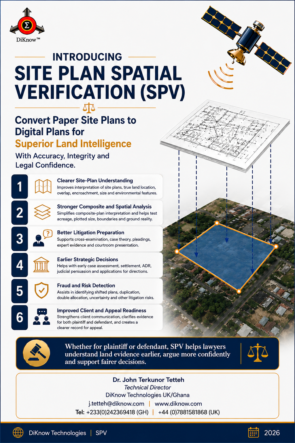
Featured professional briefing
For plaintiffs and defendants alike, spatial verification can reveal the questions that should be asked earlier—before a defective location, overlap or composite plan shapes the direction of a case.
Clarify true location, acreage, overlap, encroachment and surrounding features.
Support pleadings, cross-examination, case theory and expert evidence.
Identify shifted plans, duplication, double allocation and spatial uncertainty.
Ghana civil proceedings
SPV can cross-check a court surveyor’s composite plan against the original site plans, help counsel frame precise technical questions and support a suitably qualified party expert where the court permits.
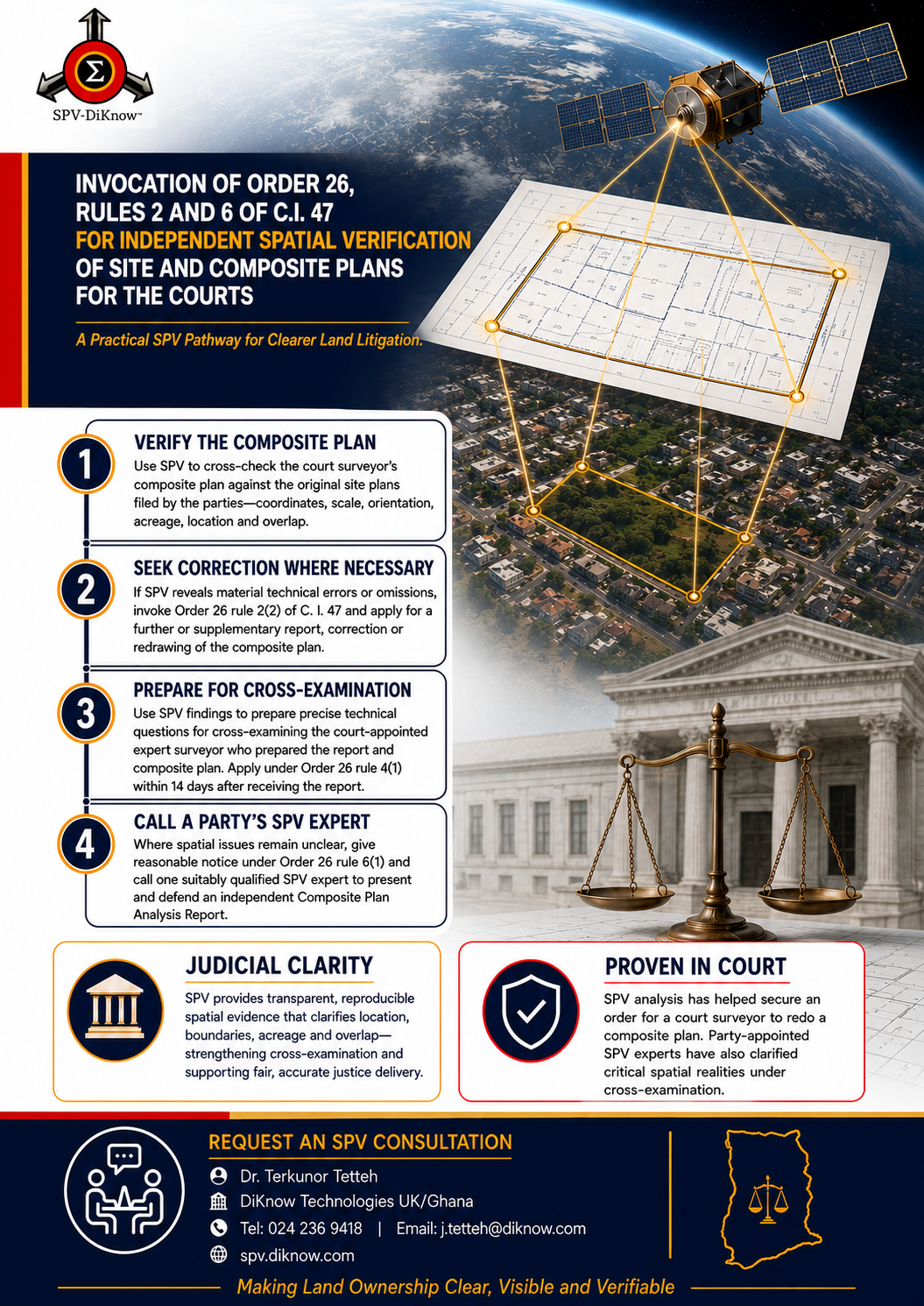
Service offering
Configured for the relevant African country, engagements can begin with a focused projection and progress to comparative analysis, a full expert report or court support.
Discuss the right servicePreservation, polygon reconstruction, coordinate review and early-stage spatial risk screening.
Country-aware parcel projection onto suitable satellite imagery or basemaps.
A focused verification report for a single site plan and its mapped location.
Database search, ranked spatial matches, overlap statistics and comparative mapping.
Cross-plan overlap, discrepancy and court-ordered composite plan review.
Purpose-built review for banks, collateral registries, police and public agencies.
Technical reports, exhibit preparation and expert witness support for land matters.
From reaction to prevention
SPV is more than a digital plan-projection tool. It is a strategic land risk-management resource supporting better-protected investments, stronger institutional decisions, fewer avoidable disputes and more reliable land-sector outcomes.
SPV — Making Land Ownership CLEAR, VISIBLE & VERIFIABLE.Specialist leadership
Founder and Lead Developer of SPV, Dr. Terkunor Tetteh combines analytical science, chemometrics, big-data expertise and cross-sector experience to make complex site-plan evidence clearer and more useful for real decisions.
See SPV with a real use case
Request a focused presentation for your organisation, legal team, bank, professional body or land matter anywhere in Africa.
SPV provides independent spatial analysis and decision-support evidence. It does not by itself authenticate legal title, determine ownership or replace official land searches, licensed field surveys, legal advice, or decisions of the relevant authorities and courts.